The Google Maps/Google Earth Iceberg Explained
- Ash

- Dec 12, 2025
- 11 min read
Disclaimer: Information in this blog post may be distressing to some readers. Reader discretion advised.
Hello! Back in October, I wrote a blog post called "The Weird/Creepy Internet Stuff Iceberg," where I explained all the tiers of what was in the iceberg. Today, we're going to take a look at the Google Maps/Google Earth Iceberg. I found this Iceberg Chart on the subreddit /r/IcebergCharts from the user /u/semydeus. Credit to that user for creating the iceberg chart.
Reddit says, "Iceberg charts are usually images of an iceberg, captioned humorously so as to convey that the tip of the iceberg is the summation of the knowledge of most people, while the much larger submerged part of the iceberg is the sum of all knowledge of a particular topic." Basically, the further you go down the tiers of the iceberg, the weirder it gets.
The Google Maps/Earth Iceberg has 7 tiers. I will do my best to figure out what everything is, and as last time, will say if I am unable to find any information. I'll also hyperlink my sources throughout the blog rather than have a giant reference list at the end. And some of the stuff I'll have to censor to keep up with Google's guidelines (sorry).
Let me know if you enjoy these types of blog posts because I really enjoy making them!!
PIN IT

The Google Maps/Google Earth Iceberg Explained

Tier 1
UFO's - I believe this one refers to the theory about an alleged "crash" site near Antarctica (see image below). YouTube conspiracy theorists claimed that this was a UFO. In reality, this was caused by an avalanche and consisted of some ice dislodged from the mountain. I believe UFO Absturz is German for UFO crash. Tbh, this looks like an avalanche to me. One other explanation for UFOs on Google Earth could be lens flares.

Two legged cat - In 2013, this image of a "two-legged" cat went viral on Imgur. A user found it on Google Earth and uploaded it. I think it was originally believed to have been created by a glitch in Google Street View. However, The Independent debunked this image - it has been photoshopped, and the image is older than Google Street View.


Military bases - This refers to the fact that in some areas, military bases are blurred out, while in other instances, the entire military base, including its equipment, is visible. Most people online say that the bases aren't blurred out anymore, so I'm not entirely sure on this one.
Roma's cat - This refers to a confused-looking cat hanging out in a cat sanctuary called Largo di Torre Argentia in Rome. This image was taken in 2017, and the kitty cat just looks a bit derpy. Bella looks like this sometimes LOL. The image has been updated since.

Roma's Cat buffalos - In 2020, a herd of buffaloes was captured on Google Earth. Also, sometimes you can see elephants. Pretty cool.

North Korea - This refers to when North Korea wasn't on Google Maps. However, since 2013, this has changed, and people can now see North Korea on Google Maps.
black spots - This refers to areas on Google Maps that are censored with either black or white spots (kinda like how a document would be redacted). These areas may be censored due to privacy concerns, government, accident-prone areas, or just a technical issue.
Tier 2
Pideon people - This one refers to when a group of people in Tokyo, Japan, pranked the internet by wearing pigeon masks in front of a Google Street View camera circa 2013 - 2014. It is believed that the perpetrators were a group of students from Musashino Art University nearby.

Flying rabbit - This refers to a rabbit that, unfortunately, got hit by the Google car and was flown into the air. Some people say it was the rabbit jumping on its own. I'm not sure what the fate of the rabbit was.
Mars and moon - Google Earth added in the Mars and Moon feature, where you can explore them via Google Earth as well as learn about historical events (like the Moon landing). I'm not sure if it still works.
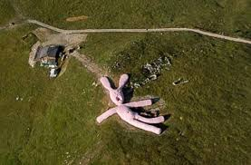
Big Rabbit - This refers to a giant pink rabbit created as a piece of artwork. The rabbit was 55 metres long and made from straw and fabric. The big rabbit is located in Prata Nevoso, Italy. It has now been removed.
Man falling down in the stairs - This refers to a man who falls backwards down some stairs in Hoboken, New Jersey, leading up to an apartment building in 2018. A bystander called an ambulance, and the man was taken away. Reddit rumours suggest that the man was about to commit a robbery. I don't know how true that is.
"F*CK YOU" roof - This one is pretty self-explanatory, but refers to a person's roof that says "F*CK YOU" that is captured by street view. The original one was in Moss Point, Mississippi, USA. Apparently, there's a lot of profanity on Google Street View if you look hard enough.
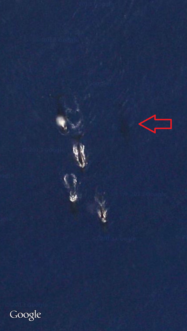
Whales - This refers to the fact that because whales are so large, you can see them from the Google Earth satellite at the top of the ocean.
Dick Church - This is a phallic-looking church located in Dixon, Illinois, USA. LOL.

Tier 3
Rainbow plane - This refers to when you look at a plane on Google Earth, it has a rainbow effect. This is because it's flying in the air and is caused by the way the cameras and satellites are designed.

Google's car pulled over - This refers to when Toronto Police pulled over a Google Street View Car, and it was captured on Google Street View. LOL.
Lady of the north - I was expecting this one to be more sinister, but it's an aerial view of some grass made to look like a woman. It's located in the UK.
S*astika Building - This refers to any buildings that look like a s*astika from an aerial view. Some are intentional, and some are unintentional. Some of the buildings may predate WWII, as the OG meaning of the s*astika is very different.
Maskered People - I believe this one refers to the masked people in Mexico (seen below). There are two explanations for this one. 1) They're either just trolling Google or 2) They dressed up for Día de Muertos and Xantolo, where people dress up to honour those who have passed (or both). Apparently, more people have gotten into this trend, so keep an eye out for any random masked people on Google Street View when exploring.

Creature on the balcony - This refers to what appears to be a creepy-looking "creature" on a balcony in Nancy, France. To me, it looked like a giant Tiki. Turns out, it's just a statue. Google Earth has since blurred the picture. It makes me sad because tikis are good luck.
Big Crab - This refers to the image below of a giant crab spotted in Kent, England. However, it's most likely fake, as I'm pretty sure the only places where there are giant spider crabs are in Japan. If you're scared of crabs like me, don't Google it. Oh god, apparently there's a giant crab in Tasmania too.

Angel - I'm not able to find the actual image anywhere except on YouTube, but this is an image of a woman who is most likely holding a dog, and a hawk comes down to nip the dog - and it makes the woman look like she has wings.
the m*rder dock - This is a picture of what people thought was a real-life m*rder in Amsterdam. However, it was just a wet dog that turned the wood darker from being dripping wet.

Underwater ship - This just refers to any sunken ship that can be seen on Google Earth. If you Google "Underwater ship, Google Earth", you're given different coordinates to search for known shipwrecks.
K*dnapper house - This is the Cleveland, Ohio house of convicted k*dnapper Ariel Castro, where he k*dnapped and held hostage 3 women for 10 years. The house is blurred out on Google Maps. The women went through 10 years of t*rture, and one of them freed herself and told a neighbour. Castro ended his life in prison. The house has since been demolished, but I think the street view still shows it.
Red sea - This refers to a lake in Iraq that looks red on Google Earth, most likely due to the sand mixing with the water, turning it a red colour. I think this one is on here because many people have mistaken it for blood.
Tier 4
Ghost Girl - This refers to the image below of a "ghost girl" taken at a cemetery at Martha Chapel Cemetery, Texas, USA. You can see a figure peeking out behind the tree, but also another figure in the background. It is a little bit creepy for sure. However, we don't know IF this image is authentic at all. Could it be that a little girl wanted to play a prank? Yes. Could it be a case of pareidolia? Yes. Could it just be a hoax? Yes.

Man pointing a g*n to the camera - Another self-explanatory one. I don't want to share the images because it's scary. But it's just a group of people, and one person is aiming a g*n at the Google camera. The location of this was Detroit, and it's also scary because where the people were standing, an infant was found deceased inside the house, and no one could work out what happened to the baby. RIP baby. This is weird.
Dog chasing Google's Car - This is a cute little doggo in Japan who chased Google's Car. I believe the doggo is okay and looks like a Shiba crossed with something. Very cute.

Donkey K*lled by Google's Car - This one is a bit sadder than above, but refers to when the Google Car hit a poor donkey. However, the donkey didn't die! It was actually a misleading thing, where the car captured images of a donkey lying down in Botswana. Yay for Donkey! Shrek will be pleased.
Kazakhstan pentagram - This refers to an area on Google Maps in Kazakhstan that is a "star" shape in a park. I don't think there's anything sinister to this one.
Sudan Lips - This refers to a hill formation that looks like landlocked lips. The image was taken in 2012 and is located in Sudan's West Darfur state. I don't think there's an explanation as to why it looks like this.

Face in the Clay - This refers to a naturally formed face that is found in Alberta, Canada. I believe it's called "Badlands Guardian".
Lost Baby - Omg, I remember this one being in the news. It refers to a Google Maps image of a baby crawling alone outside a Gucci store. This led to mass speculation that the baby was lost. However, if you move to the right of the photo, there's an adult standing just outside the story. So interesting how fast misinformation can spread.

Tier 5
Blonde tourist legs - This refers to the image below of a blonde woman in Mexico. I think this is just a camera glitch.

Oke bay snake - Hehe, this one is in New Zealand. It's an image that looks like there's a giant snake in the water, but it's probably just waves. NZ has sea snakes, but they're not this big. NZers are big pranksters.

A van on fire - This one is self-explanatory but I don't know if it's "real". If anyone has any information, let me know.
Ice ship - This refers to an iceberg in Antarctica that looks like an ice ship. It's most likely an instance of pareidolia.
Broken Face - This refers to a broken face seen on Google Maps in Hague, The Netherlands.

Plane in the forest - This one is simultaneously boring and interesting. It's a plane located in Oregon, USA, where a person purchased a plane, put it in the forest, and converted it into a home. It looks like a random lost plane in the forest on Google Maps.

Axe m*rder - Apparently, this one is a prank. A few people pranked a m*rder scene in Scotland when they saw the Google Car was arriving. The culprit had to apologise.
Ghost man - I'm not able to find the image, but it's most likely in reference to an image that resembles a ghostly man captured in an abandoned town before it was bulldozed for an airfield. I can't find a reference for this one, so I have nothing to back me up except a YouTube video I watched.
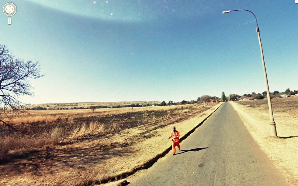
Prisoner escaping - There have been a lot of people dressing up as prisoners and pranking Google Maps. However, there is one image that is legit: a person escaping from a South African prison.
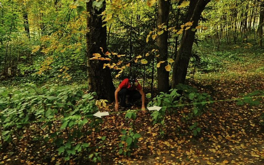
Gas mask guy - This refers to the image below where a man crouches in the forest with a gas mask. We don't know where in the world the image was taken and I can't find where it first circulated. No idea what he's doing.
Tier 6
Azura Beebeejaun - This refers to an image of a girl who faked her own d*ath as a prank for Google Maps.
Body found 22 years later - I remember reading or hearing about this case somewhere. I even think I've discussed this case on my blog somewhere. Anyway, in 1997 in Florida, a man called William Moldt went missing following a night out. He was 40 years old. In 2019, a person spotted a car in a lake on Google Maps, reported it, and they found William's body. The car was able to be seen on Google Maps since 2007, but no one had noticed it until 2019. It is thought he lost control of his car and drove into the lake. I'm not sure how true this is, but some articles say he was drinking heavily that night while others claim he didn't drink at all. Very sad. Glad his family was able to finally get some closure.
New Baltimore Ghost Town - This one sounds fun, like a real-life haunted ghost town. However, the camera just glitched back in 2013, and it has since been fixed. It would have been super creepy at the time.

41 marmol - I cannot find any evidence to back this one up, other than some YouTube videos saying that it was a body found hanging off a balcony in Mexico.
Teen m*rdered - Basically what it says, this one is real. It was an image of a 14-year-old boy who was m*rdered. His body was found in Richmond, California.
Injury cow - This refers to a cow that got scared by the Google car, and we see images of it running away. I'm not entirely sure whether it is injured or if it had been injured previously.
Children with g*ns - Yep, this one is as it sounds. It's just different Google Maps images of children carrying g*ns (some are toys and some are real). Gives me the shivers.
Tier 7
Malaysian plane - Some people have thought they have spotted planes in the water in Cambodia that could have been the infamous MH370 plane that went missing. However, most of these have been debunked as moving aircraft under light cloud coverage or unrelated wrecks.
A lake in an island in a lake in an island - What a mouthful LOL. It's literally just an island that has a lake in the middle of it. Nature. I believe it's in Canada.
R. Pref. Oscar Cunha - This is allegedly one of the spookiest streets on Google Maps. When you go to this street in Santa Catarina, Brazil, everything appears normal at first, but when you click around, it suddenly goes dark, and you see a "ghost-like" figure. Maybe a glitch? Who knows.

End of the world sign - This refers to a road in the Mojave Desert, California, where there is the word "HELL" written on the ground and an arrow pointing towards a sign that says "END". I think it's designed to discourage people from driving too far into the desert. It's been taken off Google Maps since.

Dogman - This refers to an image of a "humanoid" figure that has been spotted in the forests of the USA that has been dubbed "dogman". It's most likely the pareidolia effect.

Man Jumps in Google's Car - Unfortunately, I can't find anything about this one, but I'm guessing it's a prank of some sort. Hopefully, no one got hurt.
That's all, folks! Thank you for reading. Let me know what Iceberg Chart you'd like to see next.
Stay safe,
Ash xx


Comments